SafeStop
School Bus Routing Platform
LAUNCHING SOON
SEEKING PILOT PARTNERS

What if every bus in your fleet
ran the perfect route?

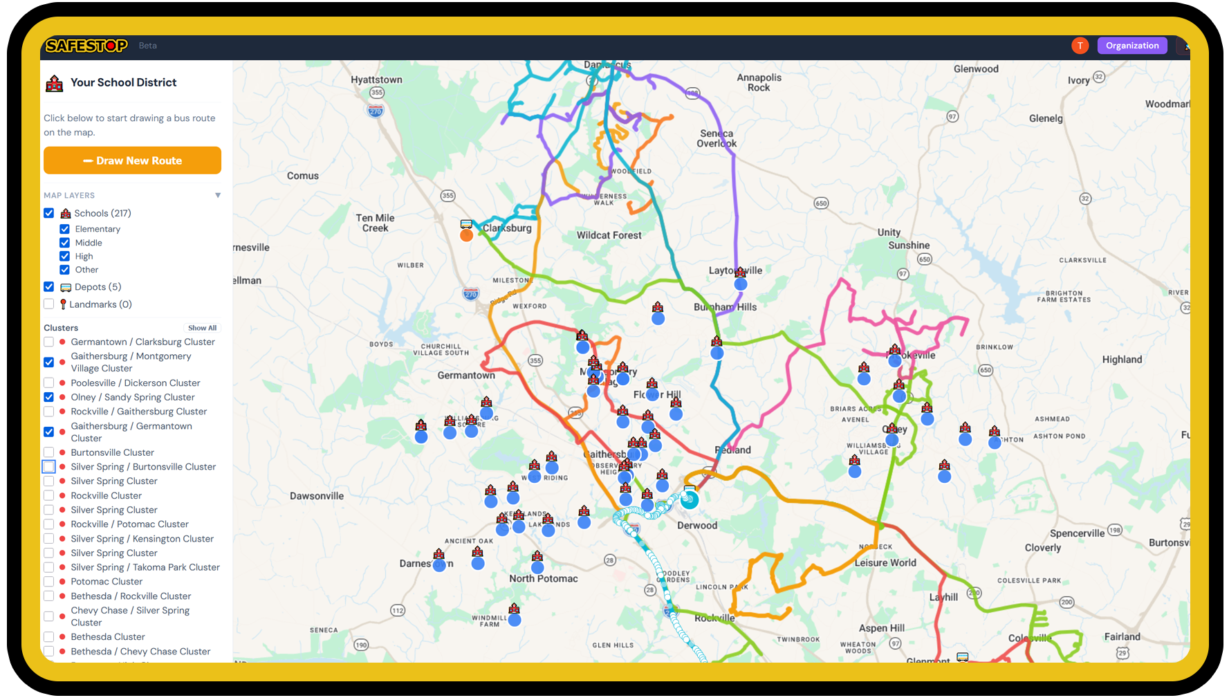
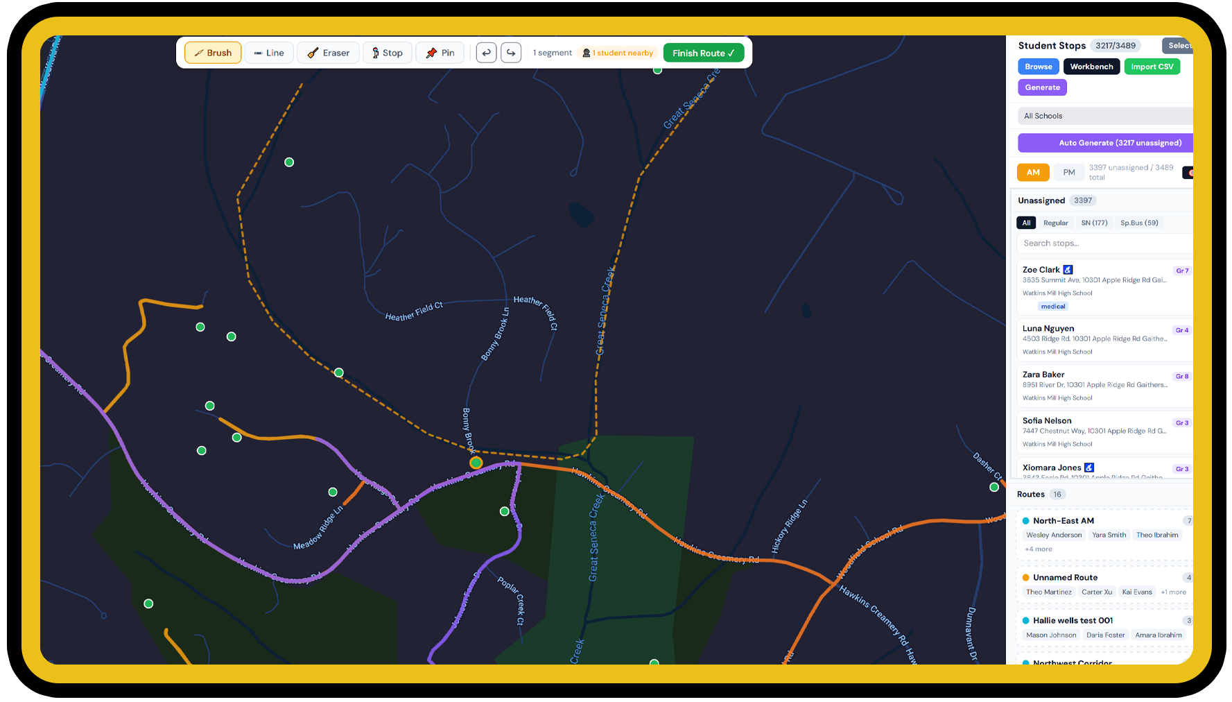
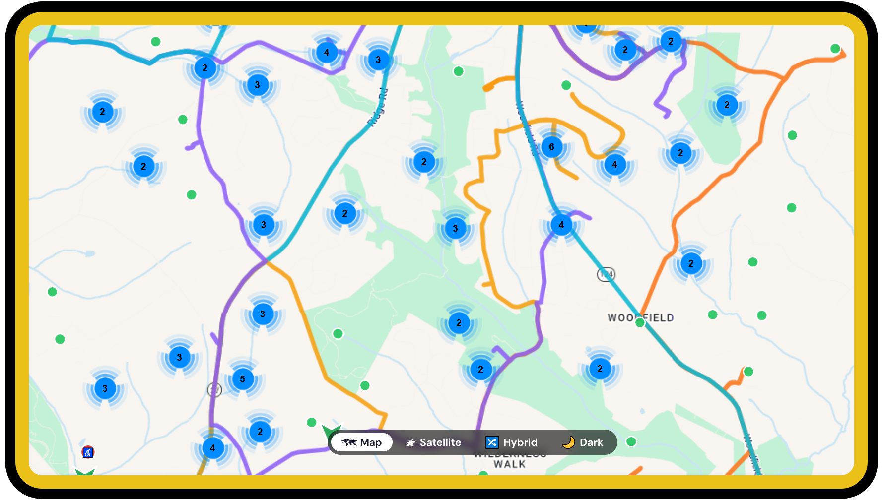
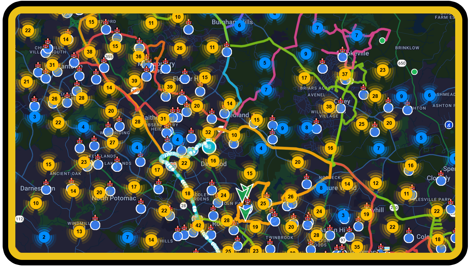
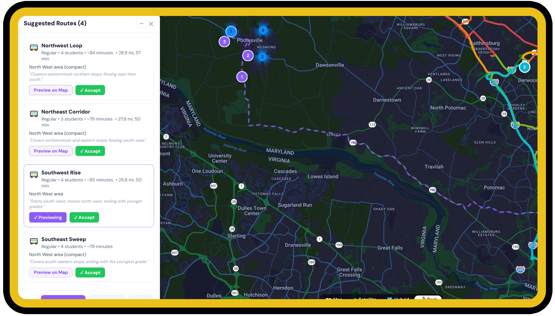
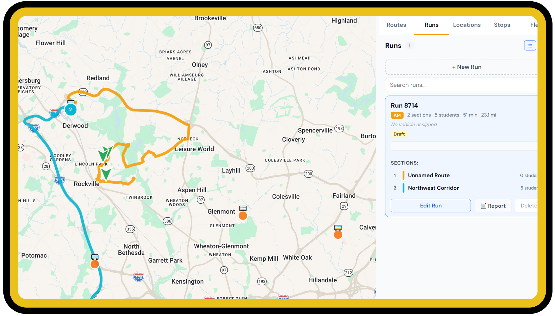
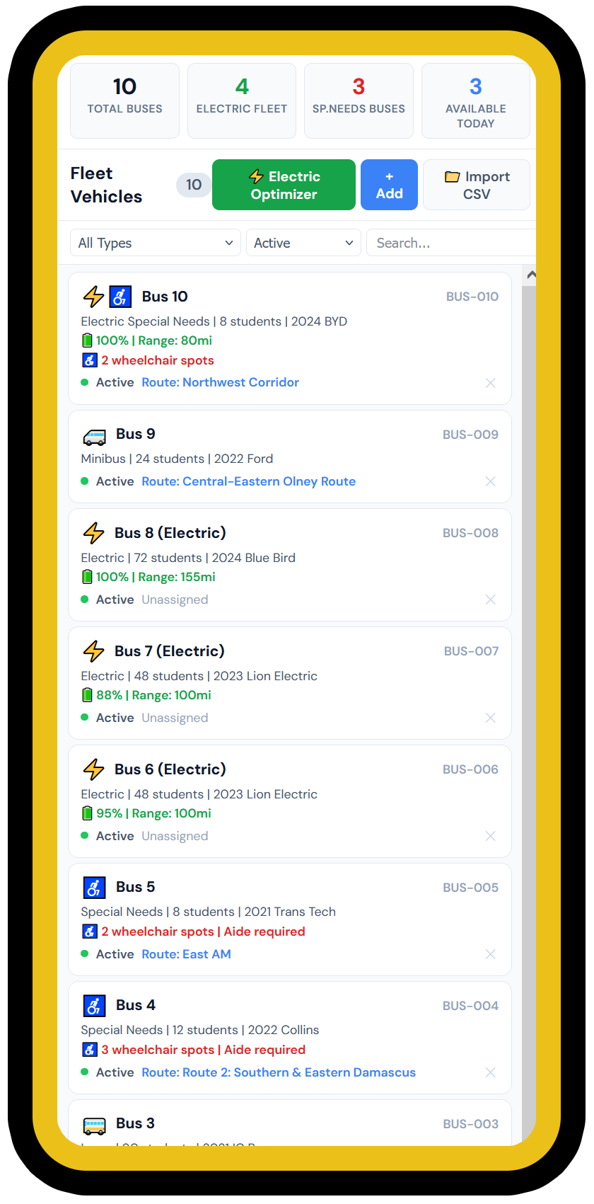
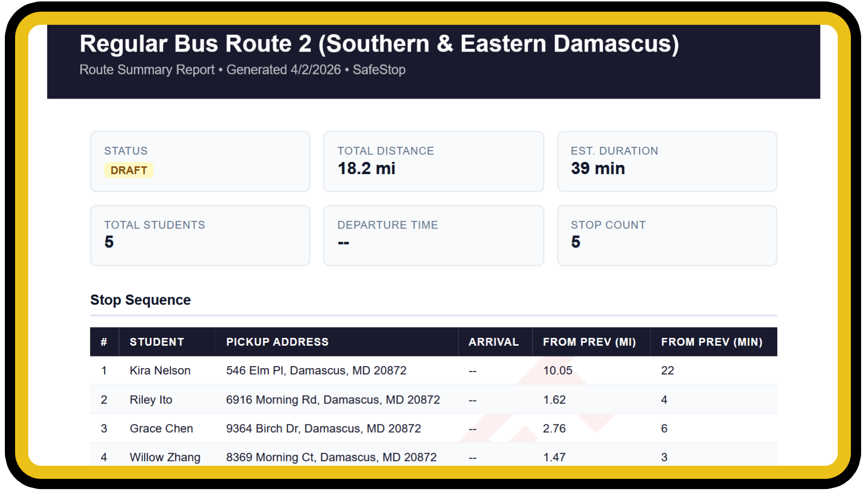
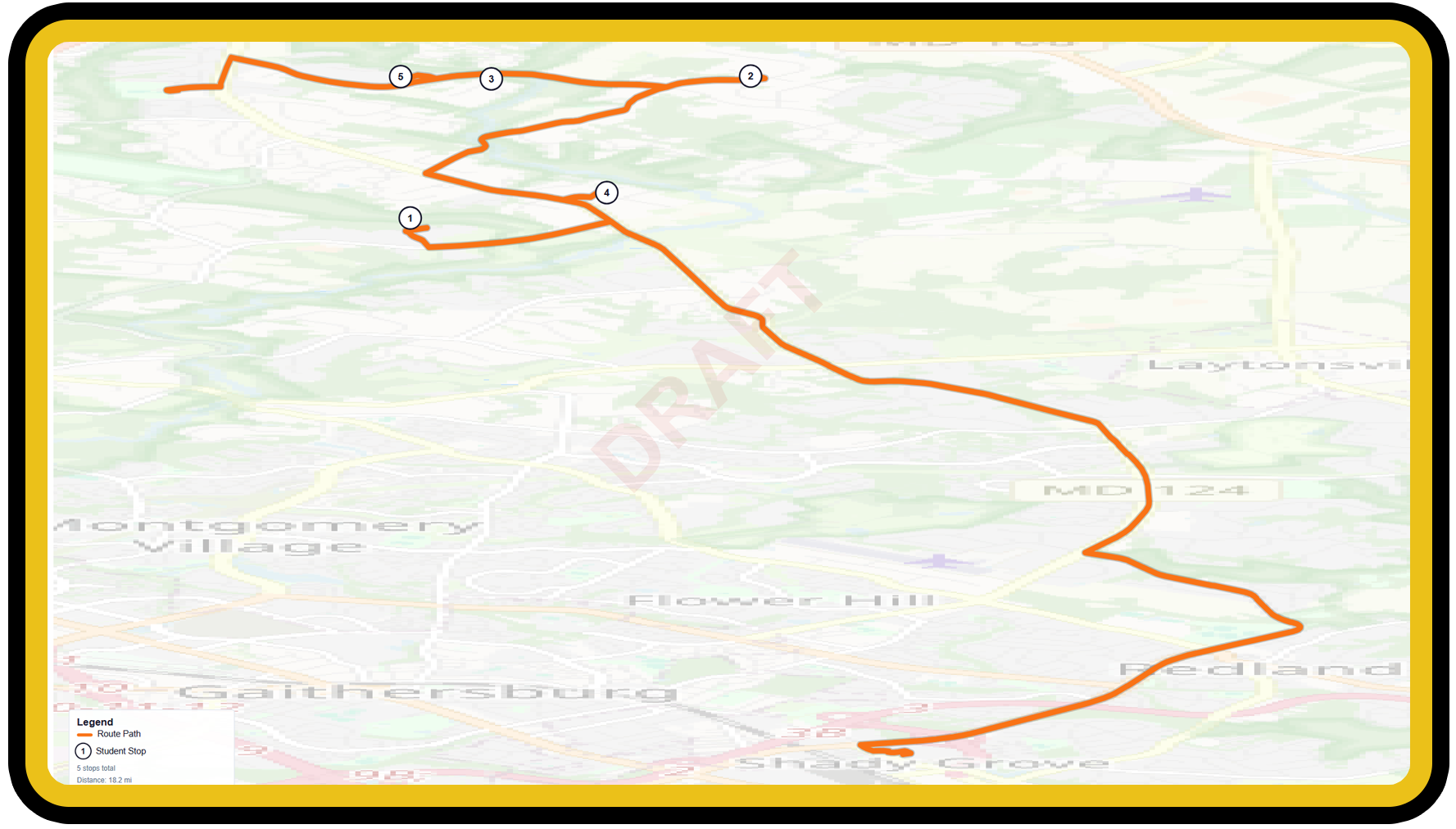
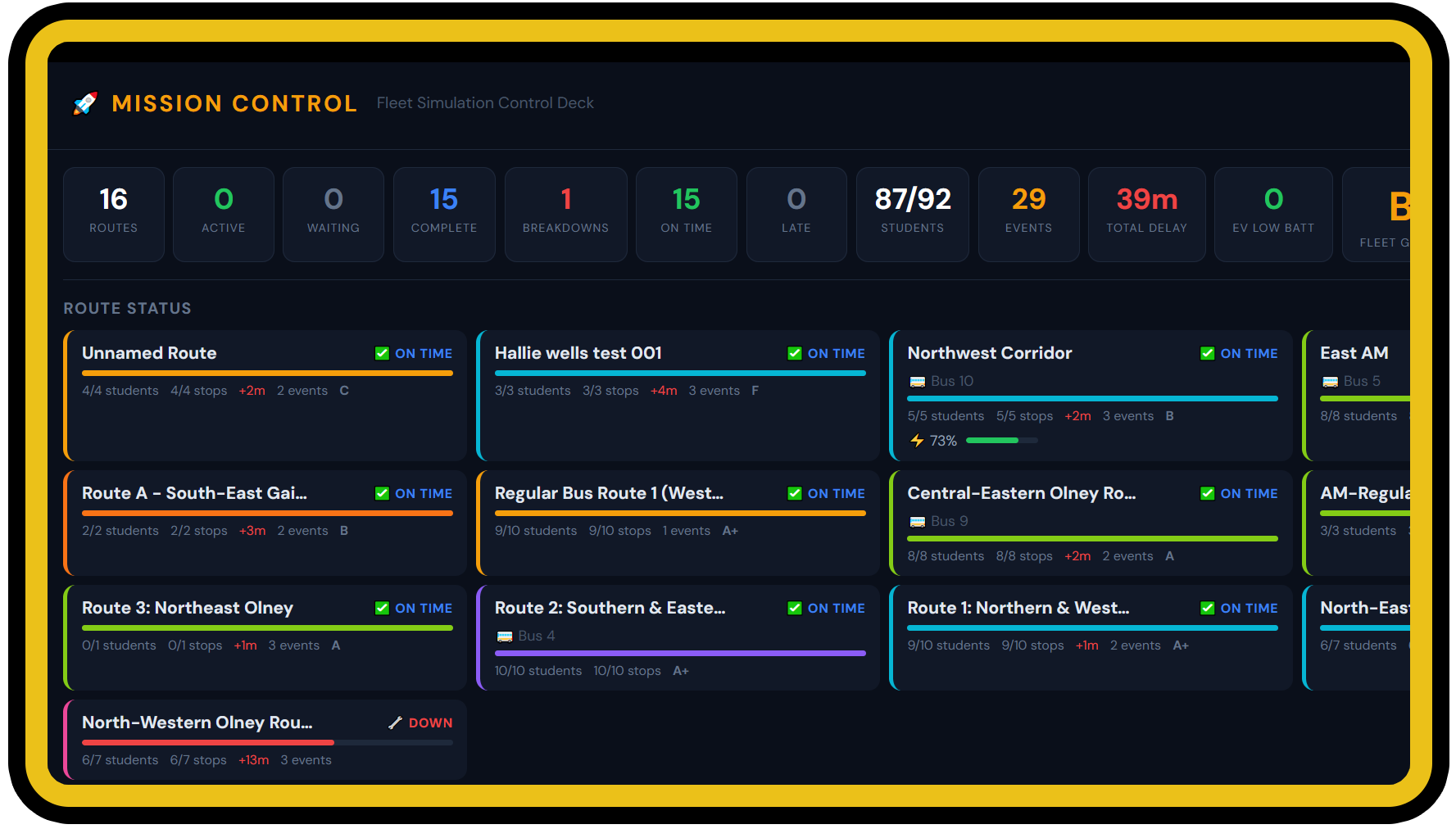
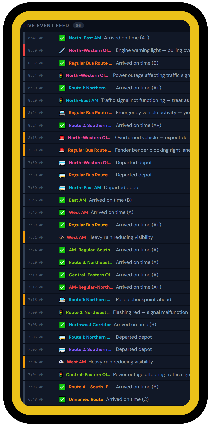
Now they can. SafeStop gives transportation teams the power to draw, optimize, simulate, and manage every route from one platform — so every bus runs smarter and every student gets home safe.

AIRoute generation
6Drawing tools
5Report types
EVFleet ready
🚀Mission Control
🏢Multi-depot
🚨 We're selecting pilot districts for our beta launch. Early partners get priority pricing, dedicated onboarding, and direct input on the roadmap. Apply for Pilot
SafeStop route overview showing multiple bus routes on an interactive map

Everything you need to route a district

From importing student data to printing driver manifests, SafeStop handles the full routing workflow.

🗺

Interactive Map Drawing

Draw routes directly on the map with brush, line, and eraser tools. Routes snap to real roads via Google Maps. Set start and end points at depots or schools — the app auto-generates the connecting path.

🚏

Smart Stop Placement

Place central bus stops on the map, then drag students to them. Students show dotted walk lines to their assigned stop. Stops get real cross-street addresses automatically via reverse geocoding.

🤖

AI Route Generation

Select a school and let Gemini AI analyze student locations, cluster them geographically, and suggest optimized routes. Preview each suggestion on the map before accepting.

🔄

Master Route Builder

Assemble individual route sections into full bus runs: depot → high school pickup → middle school → elementary. Drag-and-drop sections, compute schedules, detect conflicts.

🚌

Fleet Management

Track every vehicle — standard, special needs, electric. Monitor EV battery and range. Assign buses to routes or runs. Run fleet optimization to match vehicles to routes.

📊

Reports & Manifests

Generate route summaries, driver manifests, schematic maps, fleet reports, and run reports. PDF or HTML. Privacy controls redact student names for public copies.

🏫

Multi-School & Multi-Depot

Manage multiple schools, depots, and clusters within a single district. Each depot has its own fleet and routes. Transfer vehicles and routes between depots. Students are district-wide — visible regardless of which depot you're working from.

🛡

Special Needs Routing

Flag students requiring special buses, wheelchair positions, or aides. Separate special needs routes automatically. Track equipment requirements per vehicle.

🎮

Route Simulation & Mission Control

Simulate individual routes with animated bus travel and random events, or launch Mission Control to stress-test your entire fleet at once. Select which routes to include, watch live KPIs, and get scoreboard grading with EV battery tracking.

Route Approval Workflow

Routers submit draft routes for review. Admins approve and publish, or reject back to draft. Pending review queue with count badges keeps everyone on the same page. Full audit trail of who requested, approved, or rejected each route.

🔐

Role-Based Access Control

Three user roles — Admin, Router, and Viewer — with configurable access restrictions by cluster, school, or depot. District admins manage their own users. Super admins manage everything from a central admin console.

🎓

Built-In Interactive Tutorial

A 32-step guided tutorial walks new users through every feature — navigating the app live as it explains each tool. Draggable instruction window, progress tracking, and pause/resume support.

🚶

Walker Zones

Draw a polygon around each school to mark the area where students walk instead of being bused. Generate a starter circle from a district-wide default radius per school level, then refine vertex by vertex. Toggle visibility per school and export large-format zone maps for school staff and parents.

🧍

Street View Pegman

Drag the Google Street View pegman onto any spot on the map to inspect intersections, bus stop locations, or driveways before placing students or finalizing a route. Verify safe sight lines, sidewalk access, and curb space without leaving the app.

🖨

Plotter Print

Box-draw a region on the map, then export a clean B&W large-format PDF tuned for plotters. Paper sizes from Letter up to 60×96 inches, per-layer toggles to control what appears, plus scale bar, north arrow, and planner signature line. Ideal for dispatch wall maps and pre-route planning sessions.

User Guide

Follow these steps to set up your district and start routing. Click each step to expand.

1

Set Up Your District

Add your depot, schools, and landmarks

Adding Locations

  1. Click the Locations tab in the right panel.
  2. Click + Add Location.
  3. Enter the name, type (School, Depot, or Landmark), and address.
  4. The address is automatically geocoded to map coordinates.
  5. For schools, select the school level (Elementary, Middle, High, Pre-K, Charter).
Tip: Use the Discover District feature to automatically find all schools in your county via the NCES database.

School Clusters

Group schools into clusters (e.g., "North Zone", "South Zone") to organize routing by geographic area. Clusters help filter students and manage routes for specific regions of your district.

2

Import Students

Batch import from CSV or add individually

CSV Batch Import

  1. Click Stops tab → Import button.
  2. Upload a CSV file with columns: studentId, studentName, grade, address, schoolId
  3. Optional columns: specialNeeds, specialNeedsType, requiresSpecialBus, requiresAide, pickupExtraMinutes
  4. Addresses are automatically geocoded and students appear as green dots on the map.

Special Needs Flags

FlagEffect
requiresSpecialBusStudent needs a wheelchair-accessible or special vehicle
requiresAideRoute requires an aide on the bus
pickupExtraMinutesExtra dwell time at this stop (e.g., wheelchair loading)
Tip: You can also generate sample student data for testing via the Stops tab menu.
3

Draw Routes

Use map tools to create bus routes

See the Route Drawing section below for the full tutorial.

4

Assign Students to Routes

Drag, drop, or auto-assign

Three Ways to Assign Students

🗺 On the Map

Select the Stop tool while drawing. Drag a student pin onto the route line or onto a placed bus stop. The student flashes green to confirm.

📋 From the Stops Tab

In the Stops tab, drag a student pill from the unassigned list onto a route card below. Or use bulk selection with checkboxes.

🤖 Auto-Assign

When you save a drawn route, students within ~350 feet of the route path are automatically assigned. Students already on other routes are never reassigned.

Duplicate protection: A student can only be assigned to a route once. Attempting to add them again is silently ignored.
5

Build Runs & Assign Vehicles

Assemble sections into master routes, assign buses

See the Run Builder and Fleet Management sections below.

6

Generate Reports & Publish

Print manifests, review, and publish routes

See the Reports section below for all report types and options.

Route Drawing

Draw routes directly on the map with professional-grade tools.

Drawing a bus route on the map with brush tool

Drawing Tools

🖌
Brush — Click and drag to freehand-paint a route path. Hold Space to temporarily pan the map without interrupting your drawing. The path automatically follows road geometry after snapping.
Line — Click to place waypoints, double-click to end a segment. Great for long straight sections or precise control.
🧹
Eraser — Drag over your drawn route to erase sections. Useful for correcting mistakes before finishing.
🚏
Stop — Click on the map to place a central bus stop (green arrow). Drag student pins to the stop or to the route line to assign them. Right-click a stop to delete it.

Start & End Points

Before drawing, select a Start and End location from the dropdowns above the toolbar. When you finish the route, SafeStop auto-generates the fastest driving path from your start location (depot or school) to where you began drawing, and from where you stopped drawing to the end location.

Locations are organized by type: Depots first, then schools grouped by level (High, Middle, Elementary, Pre-K, Charter).

Editing an Existing Route

Click any route in the Routes tab to select it, then click Edit. In editing mode, the full drawing toolbar is available:

  • Edit mode (default): drag vertices to reshape the route
  • Brush/Line: draw new path segments, then click Merge into Route to append them
  • Stop/Eraser: same functionality as during initial drawing

Undo & Redo

Ctrl+Z undoes the last action. Ctrl+Y redoes. This works for drawing segments, eraser strokes, bus stop placement, bus stop deletion, and student removal.

Route Drawing Workflow
1 Select Start / End locations
2 Draw with Brush or Line tool
3 Place stops, assign students
4 Click Finish Route
5 Route snaps to real roads
6 Nearby students auto-assigned
7 Name, save, and publish
Map Layer Controls

Use the Map Layers panel (left sidebar) to toggle visibility during drawing:

  • ✅ Schools (by level: Elementary, Middle, High)
  • ✅ Depots
  • ✅ Landmarks
  • ✅ Clusters (with Show/Hide All)
  • ✅ Student Stops (with walk lines toggle)
  • ✅ Stop filter (All / This Route / Unassigned / By School)

The Snap to Stop toggle in the Stops tab controls whether clicking a student auto-pans the map to their location.

Stops & Bus Stops

Routes with student stops on the map Stops tab with student assignments

Student Stops vs. Central Bus Stops

Student stops are individual home locations imported from CSV. Each student has an address, grade, school assignment, and optional special needs flags.

Central bus stops are physical pickup points you place on the map where multiple students gather. When you drag a student to a bus stop, a dotted "walk line" appears showing the walking distance. The student's home address is preserved, but reports show the bus stop's cross-street address (e.g., "Main St & Oak Ave" or "400 block of Elm St").

Stops Tab Features

  • AM/PM toggle — Switch between morning and afternoon route assignments
  • Filter bar — All / Regular / Special Needs / Special Bus
  • Search — Find students by name, address, or ID
  • Drag-and-drop — Drag student pills onto route cards to assign
  • Bulk operations — Checkbox selection with bulk assign, bulk school assignment, and auto-generate for selected
  • Snap-to toggle — Enable/disable map auto-centering when hovering students

Undo & Delete Protection

Deleting a student from the map requires a two-click confirmation (click once to arm, click again within 3 seconds to confirm). Accidental deletes can be reversed with Ctrl+Z. Full undo/redo support covers drawing, erasing, student removal, and bus stop edits.

Special Needs Indicators
Requires Special Bus Wheelchair or specialized vehicle needed
Requires Aide An aide must ride on this route
Special Needs General special needs flag (IEP, behavioral, etc.)
+N min Extra pickup dwell time for loading assistance
AI-generated route suggestions with map preview
AI Route Generation

Select a school, set constraints, and let AI do the work:

  • 🏫 Filter by school — only that school's students
  • 👥 Max students per bus (10-90)
  • ⏱ Max ride time (15-120 min)
  • 🚧 Avoid railroad crossings
  • ♿ Separate special needs routes
  • 🔒 Privacy: only addresses & grades sent to AI

Master Route Builder (Runs)

A single bus often serves multiple schools in sequence. The Run Builder lets you assemble these sections into a complete bus run.

Master Route Builder with run sections and timeline
Depot 6:30
HS Pickup 6:40-7:15
MS Pickup 7:25-7:55
ES Pickup 8:05-8:30
Depot 8:45

Example AM run: one bus covers high school, middle school, and elementary pickups back-to-back.

Building a Run

  1. Go to the Runs tab and click + New Run
  2. The 3-column builder opens:
    • Left: Available route sections (searchable, filterable by school)
    • Center: Timeline builder with drag-and-drop reordering
    • Right: Live map preview showing all sections
  3. Click + on a route to add it as a section
  4. Drag section cards to reorder them
  5. Set the departure time and click Compute Times to cascade the schedule
  6. Click Generate Connectors to compute driving paths between sections (deadhead)
  7. Assign a vehicle from the dropdown
  8. Click Save & Close

Schedule View (Gantt)

Toggle to the schedule view icon in the Runs tab header to see a Gantt-style timeline of all runs from 5 AM to 6 PM. Each row shows a run's sections as colored blocks with deadhead gaps between them.

Conflict Detection

SafeStop automatically checks for scheduling conflicts — when the same vehicle is assigned to overlapping time windows. Conflicts appear as a yellow warning banner and are highlighted in both list and schedule views.

Builder Layout
Route Picker
🟠 HS North AM
🟣 MS Route 3
🟢 ES South AM
Timeline
1. HS North AM
6:40 → 7:15
↓ 3.2 mi deadhead
2. MS Route 3
7:25 → 7:55
Map
🗺
Timeline Bar

Each run card and the Gantt view display a proportional timeline bar:

HS
MS
ES
6:308:45

Fleet Panel

Vehicle Types

TypeTypical CapacityNotes
Standard72Full-size school bus
Large84-90Extended capacity
Special Needs8-12Wheelchair positions, aide seat
Electric48-72Battery tracking, range analysis
Electric Special Needs8EV + wheelchair + aide
Minibus24Smaller routes or mid-day
Van8-14Special ed transport, field trips

EV Fleet Management

For electric vehicles, SafeStop tracks battery capacity (kWh), range per charge (miles), charging time, and current charge percentage. When assigning an EV to a route, a range analysis shows whether the bus can complete the route on a single charge.

Fleet Optimization

The fleet optimizer matches available vehicles to routes based on capacity, special needs requirements, and vehicle type. It suggests assignments and highlights conflicts.

Master Route Assignment

Vehicles can be assigned to individual routes or to master routes (runs). The assignment dropdown groups options: "Runs (Master Routes)" and "Individual Routes" with section counts and student totals.

Fleet management panel with vehicle cards

Reports & Manifests

Route summary report with stop sequence table Route schematic map for wall display
📄

Route Summary

Stop sequence table with pickup addresses, arrival times, distances between stops. Includes route metadata: total distance, duration, student count, departure time.

PDF / HTML
📋

Stop Manifest

Driver copy: Student names, IDs, and addresses. Public copy: Grade levels only (names redacted for privacy). Central bus stop addresses shown as pickup location with home address noted.

PDF / HTML
🗺

Route Schematic

SVG/PDF map with OpenStreetMap road background, route path overlay, numbered stop markers, north arrow, scale bar, and legend. Standard 36"×24" output for wall display.

PDF / SVG
🚌

Fleet Summary

Table of all routes with school, cluster, stop count, students, distance, duration, status, departure time, and bus assignment.

PDF / HTML
🔄

Run Report

Master route report with timeline visualization, section-by-section table (schools, students, times), deadhead distances, vehicle info, and per-section stop manifests.

PDF / HTML
🖨

Plotter Print

Interactive large-format map export. Box-draw a region on the map, choose a paper size (Letter through 60×96"), toggle which layers appear, and download a B&W PDF with scale bar, north arrow, and planner signature line. Sized for any plotter or wall.

PDF
🚶

Walker Zone Map

Per-school walker boundary export. Shows the school location, the walker polygon, and surrounding streets. Useful for sharing with families, school staff, and the district office to communicate who is eligible for busing.

PDF

Simulation & Mission Control

Test every route against real-world conditions before the first bus rolls out.

Mission Control fleet simulation dashboard with KPIs and route status
Mission Control live event feed

🚀 Live Fleet Operations

Mission Control runs all your routes simultaneously on a shared simulation clock. The KPI strip tracks active routes, delays, breakdowns, and fleet grade in real-time. The event feed streams incidents across every route as they happen.

Speed controls go up to 100x — simulate an entire morning in under a minute. Designed for hundreds of routes with no map animation, just pure statistics.

🎮 Single Route Simulation

Watch an animated bus travel a route on the map in real-time with adjustable speed (1x–10x). Live stats panel, event log, and EV battery gauge update as random events unfold.

🎲 10 Random Event Types

Student cancellations, traffic accidents, road closures, weather hazards, construction zones, signal outages, police activity, mechanical breakdowns, special ed equipment failures, and health emergencies.

📊 Scoreboard & History

Every simulation gets a letter grade (A+ through F). Save results to build a history per route. Use Mission Control to simulate your entire fleet and get a fleet-wide score. EV battery start/end and mid-day charging estimates included.

🔋 EV Battery Modeling

Simulations track battery consumption per mile, HVAC/idle drain, and warn when charge drops below the reserve threshold. Configurable starting charge, consumption rate, and charging speed in Settings.

🚀 Mission Control

Full-screen fleet operations deck. Launch all routes on a shared clock (up to 100x speed), monitor live KPIs, route status cards with progress bars, and a streaming event feed. Designed for hundreds of routes — no map animation, pure statistics.

⚙ Configurable Settings

Control event frequency (Minimal to Chaos), perfect run chance, per-event-type weights, school bell times, schedule variants (2-hour delay, early dismissal, half day), and EV fleet defaults — all from Settings.

Pilot Partner Pricing

We're launching soon and selecting pilot partners now. Early adopters lock in founding-member rates and get direct influence on the product roadmap. No per-student fees, no surprise overage charges.

🔒

View Beta Pricing

We're selecting pilot districts for our launch. Tell us about your district and we'll share founding-partner pricing — available only during beta.

We respect your privacy. No spam, no cold calls. Information is used only to prepare your personalized quote.

FAQ

What data do I need to get started?+
At minimum: a CSV of student addresses with school assignments, and the addresses of your depot(s) and schools. SafeStop geocodes everything automatically.
Is student data sent to third parties?+
Student addresses are sent to Google Maps for geocoding and route snapping. For AI route generation, only addresses and grade levels are sent to Google Gemini — student names, IEP details, and condition types are never shared.
Can I undo mistakes?+
Yes. Ctrl+Z / Ctrl+Y works for drawing, erasing, bus stop placement/deletion, and student removal. The undo stack tracks all actions in the current drawing or editing session.
How does the auto-start/end work for routes?+
Before drawing, select a Start and End location from the dropdowns (depot, school, etc.). When you click Finish Route, SafeStop generates the fastest driving path from your start point to where you began drawing, and from where you stopped to the end point. The entire path then snaps to roads.
What's the difference between a Route and a Run?+
A Route is a single trip (depot → student stops → school). A Run (Master Route) is the full sequence of routes a single bus executes — e.g., HS pickup, then MS pickup, then ES pickup. Runs let you schedule a bus's entire morning or afternoon.
Does SafeStop support electric buses?+
Yes. The Fleet Panel tracks battery capacity, range per charge, charging time, and current charge %. Range analysis warns when a route exceeds a vehicle's charge. The upcoming simulation mode will model battery consumption across full-day runs.
How many students can the system handle?+
SafeStop has been designed for districts of all sizes. The map uses marker clustering for large student sets. AI optimization processes up to 500 students per batch (larger sets are automatically chunked). There's no hard limit on routes or vehicles.

Be a Founding Partner

We're launching soon and looking for forward-thinking districts to pilot SafeStop. Early partners get priority pricing, dedicated support, and a seat at the table shaping the product.

Request a Demo

Tell us about your district and we'll set up a personalized demo environment for you.

Demo access requires a Google account for sign-in. We'll review your request and grant access within 24 hours.

🚌

Already have access?

Sign in to your SafeStop dashboard to manage routes, fleet, and students.

Sign In to SafeStop

Need help? Contact info@605media.net

© 2026 605 Media LLC. SafeStop is a registered trademark. All rights reserved.